27 Jun 2021

Winchcombe Rocks

Gloucestershire has an extremely rich and varied geology.

From the Carboniferous Limestone and Pennant Sandstone of the Forest of Dean that is underlain by huge thicknesses of Old Red Sandstone, through the ‘New Red’ sandstones and Lias clays of the flatter Severn Vale, to the Middle-Jurrasic Oolitic Limestone that forms the Cotswold hills, there is a lot going on.

For crying out loud, it’s recently taken delivery of some extra-terrestrial deposits all the way from the asteroid belt; just off Jupiter.

Winchcombe itself, the focus of this piece, sits very near to the edge of the Cotswold escarpment; nestled within an undulating, natural bowl formation with the escarpment to the south, Langley & Gretton Hills to the northwest and north, respectively, and Stanway Hill and Sudeley to the northeast and east, respectively.

This natural formation makes winchcombe a unique place. It has myriad hills and numerous rights of way or trails navigating many of them. These include The Winchcombe Way, The Gloucestershire Way and the Cotswold Way, which stretches all the way from Chipping Campden to Bath.

From churches to humble cottages, like most Cotswold settlements, Winchcombe has been imbued with a mellow, warm character from the golden yellow colour of the stone - to which many ‘honey-pot’ Cotswold towns owe their modern popularity and prosperity.

Once a significant settlement earning mention in the domesday book; its residents’ coffers filled by the wool trade, it was, at one point in history, regarded as the capitol of england (check reference). Winchcombe is now a simple, market town - although, it rarely hosts a market.

Whilst the prosperity that saw Winchcombe ascend to such lofty heights has gone, there remains many fine examples of high quality homes, some of considerable size or architectural quality, that demonstrates historic wealth. Almost all are built from the local stone; the characteristics of which make it a very good, and highly sought after, building material.  

The gargoyles of St. Peter’s Church offer a really fine example of the affinity of Cotswold stone for not just Ashlar but banker work and stone carving, as well as more regular rubble and walling material. Out on the trails, this can be witnessed up close courtesy of the Guiting Hare and Frog statues (place pin marker and photograph).

The Cotswold Hills are composed from three different geological stages of the Jurassic period; dating from between 210-140 million years ago. The steep escarpment to the west of the Cotswolds exposes sections through Lower and Middle Jurassic rocks. It is these Middle Jurassic rocks that are the characteristic 'Cotswold Limestones'.

‘Cotswold stone’ is subdivided into the Inferior and Great Oolite Groups.

The Inferior Oolite, which caps the main north-west facing escarpment, is composed of up to 100m of oolitic limestones including the Cheltenham freestone - quarried most extensively at Leckhampton and used widely in the distinctive Regency architecture of Cheltenham.
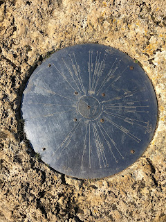
The Inferior Oolite Group can be seen in the numerous exposures along the western facing scarp of the Cotswolds. Composed of up to 100m of oolitic limestones, including the Cheltenham freestone - quarried most extensively at Leckhampton and used widely in the distinctive Regency architecture of Cheltenham, this group is described as soft, yellow, sandy limestone at the base, but gives way to more solid rocks as the sequence moves upwards to thick beds of fine-grained oolitic limestones of the Birdlip Limestone Formation (found most clearly at Cleeve Hill, Leckhampton), which were widely used as a high quality building stone.

Towards the top of the Inferior Oolite the limestones become more fossiliferous and are widely referred to as ‘grits’ due to their coarser texture. Unfortunately, the way the Inferior Oolite is exposed, particularly in places like Cleeve Cloud, as a broad vertical face of stone, it is not possible to appreciate the grip afforded by the exposed grit and fossils but, as I ride by in blur, along the thin ribbons of trail that criss-cross the cloud, I often see climbers taking full advantage of it.

In reality, riding trails in the Cotswolds, particularly if you venture away from the escarpment itself, you’ll most likely, with infrequent exception, experience conditions more attributable to the Great Oolite.
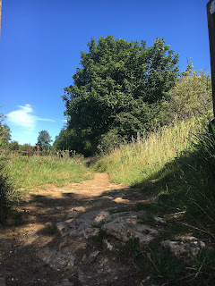

The Great Oolite, sitting above the Inferior Oolite and forming the base to much of the rather barren Cotswold plateau, encompasses a variety of oolitic, shelly, sandy or marly limestone beds, many of which are used for building purposes such as dry-stone walling and roof tiles. Generally paler, off-white to grey, in places varying to brown, and course in texture.

Where exposed, the stone is often fragmented and comes in all shapes and sizes; from dinner plate (and bigger) sized slates with ragged edges and course surfaces, to small, fist sized stones. These loosely assembled pieces of stone are all glued together, mostly, by a sandy, gravelly silt that dries almost as hard as concrete in the summer (before blowing out entirely to emulate beach like sand) but in wetter conditions becomes a killer of components with its grainy, abrasive texture.

Further afield (away from the escarpment, right up on the plateau, the golden hue of the stone has mixed with the overlying muds to create something even worse. Of a sticky, claggy, clay-like consistency and orange in colour, when wet, Cotswold Mud is the devil’s work.

Up on the plateau, there are small areas where traffic, weather, erosion has exposed more of the stone beds; particularly on steeper topography, which leads to the presence of pockets of loose, rocky trails. Away from the escarpment, however, these tend to be isolated sections where the trails are more focussed but, in most cases, the trails and bridleways pass through open fields and common land that undulates with less amplification.

The trails themselves are more indicative than defined and the ground more ‘muddy’ than rocky. This stuff, in wet conditions, will very quickly stick to your tyres, making them appear as though some new form of fat fat tyre and making a mockery of bike design and tyre clearance; eventually, bringing the whole motion thing to an unquestionable halt.

And, you don’t need to venture far from the escarpment to find such conditions. Over the top of Cleeve Common, the exposed trails aren’t too bad but even here, where less obvious, they can become quite messy in winter. However, even where compacted, the binding is more sandy than claggy, and rideable, but venture over to the far side, at the end of the Gallops, and the trails change from the blonde, sandy colour to a much deeper shade of orange. In the summer, these trails ride fine, eventually joining back to the more rocky, exposed trail behind Belas Knapp but in winter they will stop you in your tracks, quite literally.

I quite like a ride to be rounded in terms of trail type, technicality and flow and some of the best routes in the Cotswolds tick all three with blinding sections of singletrack mixed with some wooded loam, some high tech drop ins and flat out rocky descents. I think I tend towards the technical jeopardy of rockier trails compared to mud/rooty trails and, as such, the majority of my favourite trail sections within the Cotswolds are located somewhere along the escarpment and orientated downwards.

From Broadway and Stanton all the way to Cleeve and Leckhampton there are a fair share of rocky descents to pick from but, some of my favourite routes actually venture much further in to the depths of the plateau where peace and quiet can be appreciated amongst beautiful views and serene singletrack. They are, however,  also far more prone to weather and conditions so not as rideable as often.

Snowshill is a good example. Starting/finishing at the bottom of the escarpment, there is myriad choice of great, rocky descent back in to Laverton, Stanton, Stanway & Hailes, to name a few, but the top is just not worth it unless preceded by a few weeks of dry (and warm) weather or off the back of a heavy frost, lest you want to carry the bike for the most of it  (yes, that has happened - i thought it’d get better. It didn’t).

The great thing about the Cotswolds is that no ride is ever the same, there’s too much to choose from to be so restrictive and, no matter what the weather and trail conditions are, they’ll always be a route that works. Getting the maps out and piecing those routes together is half the fun of it (for me, at least) and knowing which routes will work and which are best avoided is simply down to experience and knowledge (I have been caught out enough times from ill begotten ventures down unsuitable trails, only to find myself scraping the clay from the tyres cos they simply won’t turn anymore before eventually giving up and dragging the bike to more suitable conditions, to know where is crap and when).


4 Jan 2021

Trigs and Marylins

Trig points and Marilyns

In Scotland you have Munro’s (see below) and in the Lake District there’s the Wainwrights (include description). There’s the Three Peaks but this would be too short lived and one cannot ride over Scafell Pike anyway, so that’s out the window. What can I do?

I can’t quite recall at what point I came to this way of thinking; only to say it was sometime earlier this year. Although that would be disingenuous, as I suspect it has been a concept growing in my mind for some time. It materialised in to a tangible plan sometime between the end of lockdown one and the start of L.2 - what started off with a blog about my local hill became a fascination with the term Marilyn.

Bredon Hill, Classified a Marilyn - Marilyn: a mountain or hill with over 150 meters of prominence located in Britain, Ireland, and the Isle of Man. The name is derived from a play on words, based on the first name of a famous American actress and the well-known "Munro" peak list of Scotland (www.peakbagger.com).

Compounded by lockdown, a growing disconnect with my bike has fueled the need for a new challenge. A different angle to the rather monotonous fare that makes up my current two-wheeled environment. I don’t want to become just another stereotypical weekend warrior, riding the same trails and bridleways week in, week out; although, that in itself, at the moment, would be a small blessing. I need a significant change of scenery or I need the current scenery to take on renewed light. I am in search of a new challenge or some other purpose to my mountain biking.

For me, the thing about riding local and, in most cases, solo during the initial lockdown and, subsequently, through the rest of the year is that my local trails are fairly tame. In time, they get boring. Although I live not too far from the Cotswold escarpment, it is just far enough to warrant vehicular assistance; thus avoiding the 20km there and back by road. With the exception of Bredon Hill, a Cotswolds outlier, which is in reach from my front door, this was not practicable during lockdown.

By comparison, my local trails, with the exception of Bredon Hill and, to a lesser extent, Dumbleton Hill, are pretty flat and technically, very…. un-technical; and, by local, I mean from my front door (#nocarnognarnotfar) and of a c.10-15km radius. I originate from Winchcombe some 15 miles from where I currently live and I am naturally drawn back to the myriad steeper, more technical trails around the escarpment and those more remote trails deep within the centre of the Cotswolds. Lockdown was pretty torturous in this regard but, as most mountain bikers will attest, I muddled through with what was at my door.

 But, that yearning for better trails has not gone away and, even if you removed the whole Covid-19 blanket from this storey, I’m not sure that renewed riding in the cotswolds would satisfy, as good as it can be. So I did some research. I googled. The nearest Marilyn classified prominences to my home include:
* Worcester Beacon;
* Bredon Hill;
* Cleeve Common;

Cleeve Hill, classified Marilyn

The three above, I have ridden to their summit numerous times. Others I can tick off include:
* Beacon Batch, Somerset;
* Black Mountain, Brecon Beacon’s.

There are, however, many more. In researching, I found that there are several hills nearby that don’t classify despite being taller than 150m. Either due to their not being a single prominence or their prominence being undermined by adjoining high ground.

I started paying attention to the OS map spot heights of my local hills and this has, subsequently, led me down a rabbit warren landing on the noble past-time of trig-bagging.


Whole. New. World

A quick scan of my small collection of OS maps has revealed a new prism through which to view the local landscape. Linking up sections of, otherwise, redundant or isolated sections of bridleway puts a new emphasis on the local trail network and has enabled me to put together some new routes previously untried.

While this may satiate my needs for the short-term, it will be short lived. Once I have ticked off local trig points, those routes and sections of Bridleway will again become isolated and redundant. However, I am planning longer term with this new interest.

So, I’m going to take up trig-bagging and, unlike most ‘bagger’s’, who do so by foot, I am going to use my mountain bike. This will be a key rule - I have to get there by bike.  Many of the local trig points will be easy enough to reach as most lack any really significant elevation but I have no intention of stopping there. My real aim from the start of all this was more aspirational. I want to ride some mountains, which leads me back to the Marilyns.

The OS built some 6500 trig points across the UK. Whilst some 300 have been lost and some are now inaccessible due to their being on private land, some also fall short of the original aspiration due to their proximity to roads and car parks, making them far too easy to ‘collect’. Depending on how well I get on, maybe I will come back to them one day but, for now, my focus will be on those that offer a challenge, in some way or another - be that because they sit atop a significant prominence, such as Snowden summit (1,086m), for example, or simply because I am able to formulate a suitable bike ride that encompasses them. Simply driving up to them and taking a photo feels a bit lame and falls short of what I am aiming for.  In doing so, I hope to collect several Marilyns along the way but I will be starting with those on the Landranger maps I initially poured over - lets ease in to this.


This is the trig point at the top of Snowshill (S5018). It sits along the Cotswold Way between Snowshill and Stumps Cross and offers views of Cleeve Hill, the Malverns and Broadway.

This is the trig pillar at Blakes Hill (S3802), which is just off the A46 at Aston Somerville, near Evesham. It sits within a small fenced copse with views of Bredon Hill, Dumbleton Hill and Snowshill
 

- Ordnance Survey Trig Points: Ordnance Survey Triangulation Station - triangulation pillar is the more formal term for the concrete columns found in the UK, however, the informal term, "trig point", is used more often. Represented by the little blue triangles on an OS Landranger maps. They tend to exist at the high point of a at the top of a

Ben Nevis, at 1344m, tops the list for highest trig pillar.
(wiki).

- Munro: a mountain located in Scotland with a height over 3,000 feet (914.4 m), although Topographical prominence is not a specific requirement, and which features on the Scottish Mountaineering Club (SMC) official list of Munros. They are named after Sir Hugh Munro, 4th Baronet (1856–1919), who produced the first list of such hills; the publication of which is usually considered to be the epoch event of modern peak bagging (wiki).

- Wainwrights: are the 214 peaks (known locally as fells) described in Alfred Wainwright's seven-volume Pictorial Guide to the Lakeland Fells (1955–66). They all lie within the boundary of the Lake District National Park in Cumbria, and all but one (Castle Crag) are over 1,000 feet (304.8 m) in height (wiki).